
Photo credit: Andriy Blokhin/Shutterstock
State officials say the storm could disrupt daily life from Saturday through early Monday.
To all Virginians planning to drive this weekend, whether for work, to see family, or just run errands—Virginia officials are asking you to pause and rethink those plans.
On Thursday, Gov. Abigail Spanberger declared a State of Emergency ahead of a winter storm expected to bring snow, sleet, and freezing rain across the Commonwealth from Saturday through early Monday.
“Our top priority is the safety of every Virginian,” Spanberger said in a press release. “State agencies are mobilized, and we are working closely with local governments and utility partners. Everyone should stay informed, avoid travel when possible, and take precautions to protect themselves and their families as this storm moves through our Commonwealth.”
The declaration comes as the National Weather Service warns the storm could make roads dangerous, knock out power, and slow emergency response, especially as conditions worsen over the weekend.
According to NWS, temperatures across much of Virginia are expected to hover near or below freezing. NWS forecasters warn that even small temperature shifts around the freezing mark could significantly change how much ice or snow accumulates, and how dangerous travel becomes.
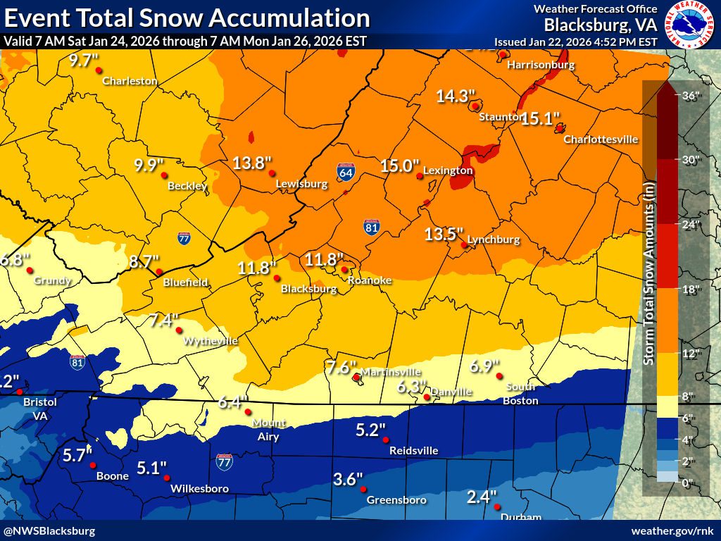
Graphic via the National Weather Service
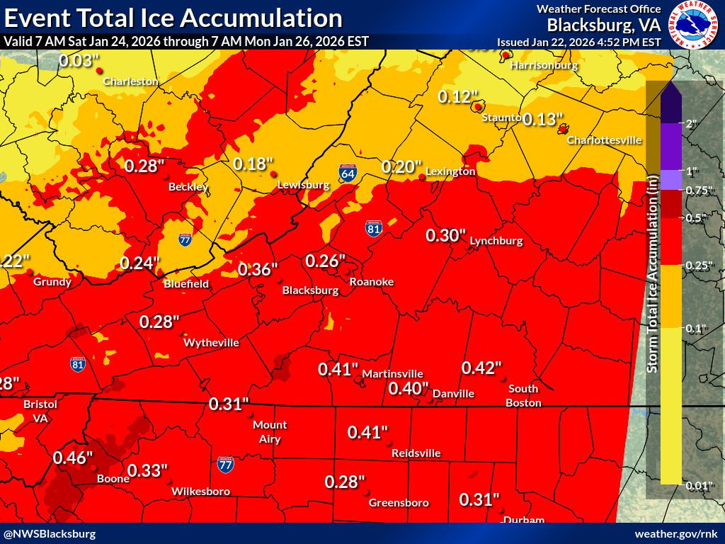
Graphic via the National Weather Service
Where the storm is expected to hit
According to the NWS Winter Storm Watch, forecasters say impacts will most likely be across southwest, west-central, central, and south-central Virginia, including parts of the Blue Ridge and Appalachian regions. Communities named in the forecast include Roanoke, Blacksburg, Salem, Lynchburg, Danville, Martinsville, Wytheville, Galax, Abingdon, Lexington, Bedford, and surrounding areas.
Wintry precipitation is expected to arrive late Saturday morning in western Virginia, spread east through the day, and reach the I-95 corridor by Saturday evening. Conditions are expected to persist through Sunday, with lingering impacts into Monday morning, particularly in eastern parts of the state.
Power outages are possible
State officials and utilities are warning Virginia residents to prepare for possible power outages, particularly in areas expected to see ice and heavy, wet snow. They said power restoration could take longer in areas hit hardest by ice if hazardous road conditions limit crews’ ability to reach damaged power lines.
Earlier this week, Dominion Energy officials told WTKR 3 that crews have been staging equipment and preparing to respond to outages caused by ice accumulation and falling tree limbs. Additionally, they said heavy, wet snow and ice pose the greatest risk to power lines, especially when ice weighs down tree limbs and infrastructure.
PJM Interconnection, the regional grid operator managing electricity for Virginia and 12 other states, issued a Cold Weather Alert from Friday through Monday, directing power generators to delay maintenance and ensure fuel supplies are ready to meet increased demand during prolonged cold conditions.
How to prepare
According to the governor’s office and the state Department of Emergency Management, Virginians should avoid non-essential travel during and immediately after the storm, prepare for possible power outages—including storing flashlights, batteries, and extra blankets in easy reach—refrain from using generators, grills, or gas-powered equipment indoors, avoid overexertion while shoveling snow, and check on elderly and disabled neighbors.
If travel is inevitable, officials suggest trying to reach destinations before conditions worsen, check road conditions, give snowplows and emergency vehicles plenty of space, and drive slowly and increase following distance.
READ MORE: Keep your pets safe during Coastal Virginia winters
What happens next
The storm is predicted to move slowly, meaning impacts could last longer than a typical winter storm. State and utility officials warn that road conditions may not improve immediately after precipitation ends, particularly if temperatures remain near freezing. Power restoration could also take time in areas hit hardest by ice and heavy snow.
To stay weather-aware throughout the weekend:
- Monitor alerts from the National Weather Service.
- Check road conditions at 511 Virginia or via the 511 mobile app.
- Follow updates from the Virginia Department of Emergency Management and local officials.
- Watch for outage updates from Dominion Energy if power is lost. If power is lost, report it calling 866-DOM-HELP or through the Dominion Energy mobile app.

No Results Found
The page you requested could not be found. Try refining your search, or use the navigation above to locate the post.
No Results Found
The page you requested could not be found. Try refining your search, or use the navigation above to locate the post.
