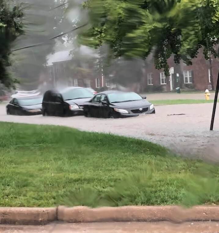
A look at Alexandria's Commonwealth Avenue after the Sept. flood.
Flooding isn’t necessarily predicable, but where floods frequently occur is.
DANVILLE – A 100-year flood only happens once every century, right? Tell that to the folks in Danville, and they’ll probably roll their eyes. Seven of the Dan River’s 10 historic crests occurred in the last 17 years. Go a bit farther north to Alexandria and you’ll get a similar response. The DC suburb has dealt with four major floods in the last three years.
While it’s hard to find funding for flood repair, state officials have another way to help. The tool helps scientists determine which Virginia rivers are more prone to flooding. And it’s available to the general public, free of charge.
The Virginia Department of Conservation and Recreation partnered with the Virginia Institute of Marine Science’s Center for Coastal Resources Management for the project. Together, they created the Virginia Flood Risk Information System (VFRIS).
According to the DCR’s website, the VFRIS helps communities, real estate agents, property buyers and property owners discern an area’s flood risk. By pulling from various resources, the VFRIS allows users to locate a property to see if it is within the Special Flood Hazard Area.
In 2017, the tool received an upgrade. It currently shows the limit of moderate wave action, changes since the last Flood Insurance Rate Map and parcel boundaries for most of the state. Users may also download flood insurance studies and flood risk reports, in addition to uploading shape files and drawing on maps.
“The Virginia Flood Risk Information System is a tool to amplify flood risk awareness. Residents can simply search their home address and receive a visualization of flood hazards within their neighborhood,” said Certified Floodplain Manager Angela Davis, DCR’s floodplain program planner. “More advanced tools are available on VFRIS for engineers to conduct analysis and alternative visualization layers to communicate risk such as depth cell grids.”
The Dan River
The Dan River, which flows through Danville, had three of its top four highest crests in less than two years. According to the National Weather Service, the Dan River crested highest on October 12, 2020 at 30.01 ft. Second, it hit 28.65 ft. on September 7, 1996. On May 23 and February 8 this year, the river respectively topped 27.57 ft. and 22.27 ft.
Chris Franks, Danville’s Chief Engineer, said you can blame weather for the high flood risk.
“There are years in which we see a lot of storms. For instance, this year, we’re in the Greek alphabet on the hurricanes. Other years, not so much. I guess it just depends on a lot of factors,” Franks said. “As far as if anything’s changed in Danville to make the flooding worse, I mean, there hasn’t really been significant development in recent memory that would affect the amount of flooding. It’s really, from what I gather, changes in the weather.”
Franks also noted the flooding problem isn’t only dependent on how much rain the city gets, but also where it occurs.
“During Tropical Storm Michael, the Dan River wasn’t flooding when we had the worst of our flooding,” Franks said. “It was just so much concentration of rain in specific areas of the city, like the Apple Branch watershed, for instance. Those tributaries through the Dan River were flooding at extreme levels, whereas the level of the Dan River wasn’t really that high.”
As for the increase in major Southside floods, Davis acknowledged a global crisis.
“Climate change! Nature always wins in the end,” Davis said. “Increased global temperatures have caused glaciers to melt, sea levels to rise and an uptick in energy in the atmosphere which all contribute to more rain falling from the sky.”
Seeking solutions
Unfortunately, wrangling Mother Nature isn’t easy.
“As far as the flooding of the Dan River, I don’t really know what we could do about that right now,” Franks said.
However, there are ways community members can help reduce flooding risks.
“It’s not really a thing that we can just kind of snap our fingers and fix it. Some of the easy ways that everybody can help is just simple things,” Franks said. “Like, a lot of times I’ll be driving around and I’ll see people piling up leaves or grass clippings, things like that, right in the gutter or right next to a storm drain. Or otherwise blocking curb inlets with trashcans and whatever else. Simple things like that. You know, making sure that the drains on your property aren’t clogged up. I think that would help a lot.”
Those experiencing flooding may look into getting insurance for their property.
“As a city, Danville participates in the National Flood Insurance Program. Participation in the NFIP makes flood insurance and disaster relief funds available to residents and businesses in Danville, no matter what flood zone their property is located within,” Davis said. “Flood insurance allows residents to bounce back quicker and the community to be more resilient post-disaster. By participating in the NFIP, Danville has committed to proactively administer smart land-use and building code practices throughout the community.”
Inland Flooding
Even though Danville sits over 200 miles from Virginia Beach, inland Virginia experiences ample flooding. Southside isn’t alone. While we think about coastal flooding during hurricane season, floods happen inland just as often when major storms come.
“Anywhere it can rain, it can flood,” Davis said. “Urban flooding has been on the radar in Virginia as some of our more densely developed areas have seen floods due to excessive runoff and storm water systems that aren’t designed to meet the capacity of the current precipitation patterns.”
Julie Buchanan, DCR’s senior public relations and marketing specialist, highlighted preparation for flood circumstances.
“Most people don’t realize their homeowners and renters insurance policies don’t cover damage from floods. They usually learn this when it’s too late, when they go to file a claim. Flood insurance can help people recover more quickly and fully after a flood,” Buchanan said. “It’s estimated that one inch of water in a home can cost up to $25,000 to repair. People should know there’s a 30-day waiting period for a new flood insurance policy to go into effect.”
An available tool
For those concerned about flooding risks, a quick look at the VFRIS could settle minds or spark plans.
“VFRIS can be used as a tool to empower people to take action against their risk,” Davis said. “This valuable tool can be used to drive conversations around areas of mitigation interest, large scale flood-control infrastructure projects, targeted outreach and more. As the age old saying goes, ‘When you know better, you do better.'”
The DCR works alongside other state agencies, communities and organizations to promote flood awareness statewide. For more on the flood risk system, you can go here. Those interested in learning more may also follow the hashtag #FloodAwareVA on Twitter.
Amie Knowles reports for The Dogwood. She can be reached at [email protected]
Support Our Cause
Thank you for taking the time to read our work. Before you go, we hope you'll consider supporting our values-driven journalism, which has always strived to make clear what's really at stake for Virginians and our future.
Since day one, our goal here at Dogwood has always been to empower people across the commonwealth with fact-based news and information. We believe that when people are armed with knowledge about what's happening in their local, state, and federal governments—including who is working on their behalf and who is actively trying to block efforts aimed at improving the daily lives of Virginia families—they will be inspired to become civically engaged.


VIDEO: Your support matters!
Your support matters! Donate today. @vadogwoodnews Your support matters! Visit our link in bio to donate today. #virginianews #virginia #community...

Op-Ed: Virginia’s new Democratic majorities pass key bills to improve your lives, but will Youngkin sign them?
The 2024 Virginia General Assembly regular session has wrapped up. It was a peculiar session from the outset, with Democratic majorities in the...

Op-Ed: Why Virginia Needs A Constitutional Amendment Protecting Reproductive Freedom
Virginia’s recent election season in 2023 drew in eyes from all over the country. Reproductive freedom was on the line and Virginia remained the...

From the state rock to the state flower, here’s how Virginia got its symbols
Have you ever wondered why the Dogwood is the state flower? Or how the cardinal became the state bird? We’re here to answer those questions and more...

VIDEO: Second-gentleman Douglas Emhoff gives speech on reproductive freedom
Second gentleman, Douglas Emhoff touched on reproductive freedom not only being a woman's issue but "an everyone's issue" during the Biden-Harris...

Glenn Youngkin and the terrible, horrible, no good, very bad night
Election Day 2023 has come and gone, and while there are votes to be counted, one thing is perfectly clear: Virginians unequivocally rejected Gov....


